Stop the Chew Moor Lane Development
A proposal for 100 homes on Green Belt land in Westhoughton is currently under consideration. Local residents have until 14 April 2026 to object.
Deadline to Oppose This Development
WHY THIS MATTERS
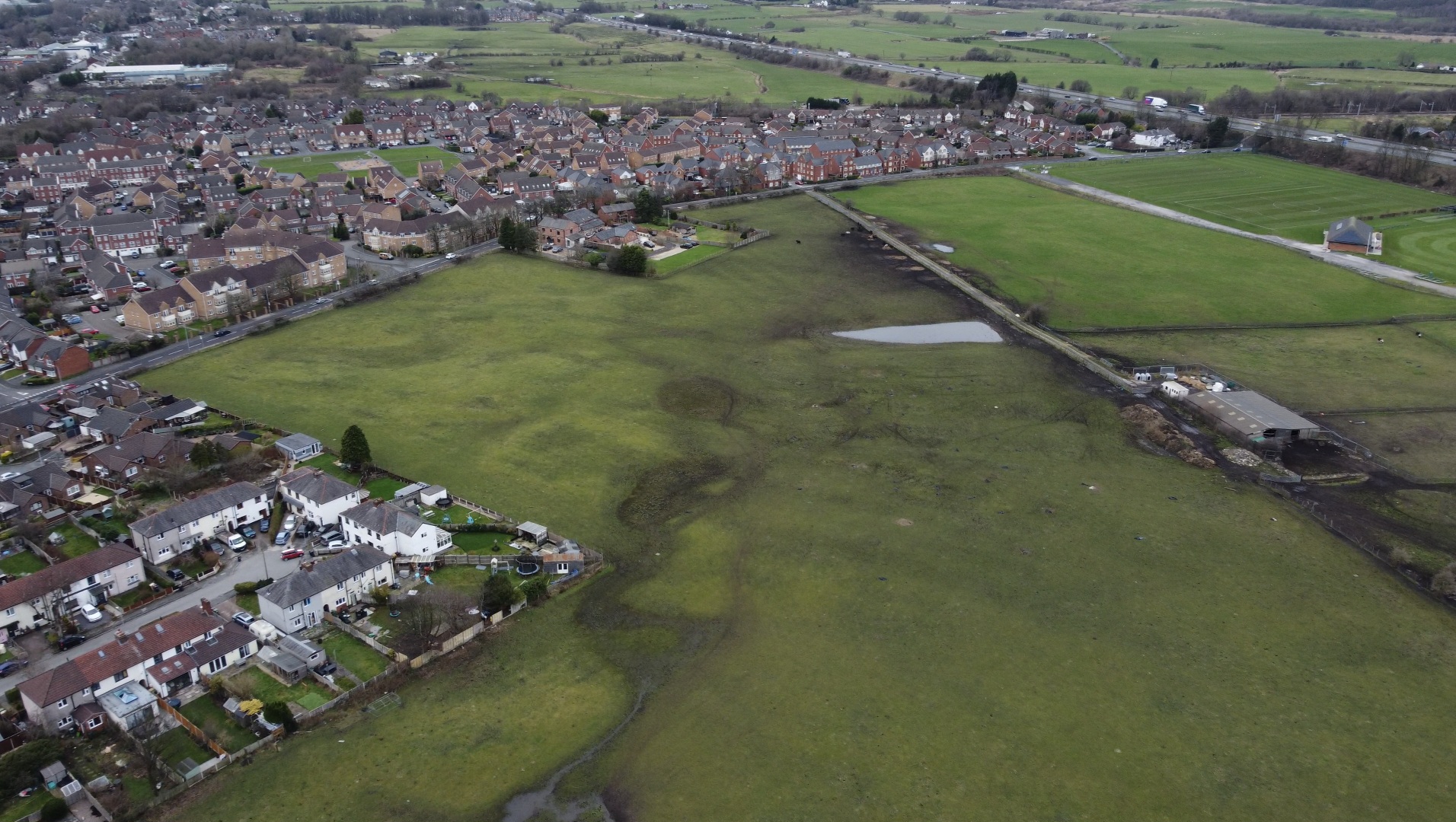
A housing development is being proposed on land off Chew Moor Lane in Bolton by Persimmon Homes. The site is currently agricultural land and forms part of the area’s Green Belt, helping to protect open space and the character of the local community.
Persimmon Homes has referred to the land as “grey belt”; however, this classification is disputed and may not accurately reflect the site’s current use or function. This website has undertaken a detailed review of the application documents and presents the key planning issues, setting out evidence-based grounds for objection.
Please familiarise yourself with the details so you can submit a strong and informed objection.
How to Object to This Application
Vist the planning portal
Press the link at the top or bottom of this page.
Register
Press the 'register here' link at the bottom of the council planning page
Login and comment
Once logged in you are able to oppose against planning ref: 21433/25
Other ways to oppose
You can send your objection by email:
planning.control@bolton.gov.uk
Include:
- Application number: 00513/26
- Your name and address
- Your objection
Write a Letter
You can also submit a written objection by post to:
Planning Control
Bolton Council
Town Hall
Bolton
BL1 1RU
Make sure to include:
- Application number
- Your full address
What Not to Include in Your Objection
To make your objection as strong and effective as possible, it’s important to focus on relevant planning issues.
The Council will only consider comments that relate to planning policy and material considerations.
❌ Avoid these points
The following arguments are not considered valid planning reasons and can weaken your objection:
- Impact on house prices or property value
- Personal opinions about the developer
- Loss of a private view
- Disruption during construction (temporary issues)
- General statements like “I don’t like it” without explanation
- Save our green Belt
Build a Strong Objection
The following points below highlight the key issues with the proposed development, based on the evidence submitted by the developer and planning policy.
Green Belt – Detailed Policy Based Objection
What the application claims
The applicant argues that:
- The site should be considered “Grey Belt”
- It does not strongly contribute to Green Belt purposes
- It is:
- “contained”
- a “logical extension” to existing development
- Nearby settlements are described as villages, reducing the importance of separation
This is used to justify development in principle.
What national policy (NPPF) requires
Under the National Planning Policy Framework:
Key principles:
❗ Green Belt should remain open
The fundamental aim is to prevent urban sprawl by keeping land permanently open
❗ Development is inappropriate unless justified
Inappropriate development is, by definition, harmful and should not be approved except in very special circumstances
❗ Five purposes of Green Belt (key ones here):
- To check unrestricted sprawl
- To prevent neighbouring towns merging
Key point:
There is no formal “Grey Belt” designation in the NPPF
So:
- It does NOT override Green Belt protection
What Bolton’s 2016 Green Belt Assessment says
The Council’s own evidence (2016) identifies the wider area as:
- Making a strong contribution to preventing urban sprawl
- Making a strong contribution to preventing settlement coalescence (merging)
It scores:
- Strong for preventing sprawl
- Strong for preventing merging
- Moderate for countryside protection
This is critical:
- It is the official evidence base
- Used to inform planning decisions
The Council evidence says:
It forms:
“a critical gap… preventing the merging… of settlements”
Where the application conflicts with policy and evidence
❗ 1. Selective reinterpretation of the site
Developer approach:
- They assess a smaller, reduced site area
Conclude:
“limited contribution to Green Belt”
Problem:
The 2016 assessment looks at the wider parcel of land
Why this is weak:
- Green Belt function is not site-specific in isolation
- It works at a landscape scale
Shrinking the site artificially reduces its perceived importance
❗ 2. Contradicting the Council’s own evidence
Council (2016):
- Strong contribution to:
- preventing sprawl
- preventing merging
Developer:
- Claims:
- limited contribution
Conflict:
The application directly contradicts the Council’s evidence base
The developer selectively narrows the assessment area to reduce the perceived importance of the site, rather than considering its role within the wider Green Belt.
❗ 3. Redefining settlements to weaken policy
Developer claim:
- Nearby areas are “villages”, not towns
- Therefore:
- Green Belt purpose (prevent merging) is less relevant
Why this is weak:
- The 2016 study already considers settlement relationships
- The distinction is being used to reinterpret policy, not apply it
❗ 4. “Logical extension” argument
Developer claim:
- Site is:
- contained
- adjacent to housing
NPPF position:
Green Belt exists specifically to:
- stop outward expansion at the edges
Why this fails:
- If every edge site is “logical”:
- Green Belt protection is undermined
❗ 5. Greenfield land
The application confirms:
- The site is undeveloped agricultural land
Policy relevance:
- Greater weight is given to protecting:
- open, undeveloped land
This weakens the “Grey Belt” argument further
❗ 6. Lack of “very special circumstances”
Under NPPF:
Harm to Green Belt must be clearly outweighed by other considerations
Developer relies on:
- Housing need
- Land availability
But:
- Housing need alone is not sufficient
- Especially where:
- policy conflict exists
Key conclusion (simple and powerful)
The application does NOT demonstrate:
- That the site fails to serve Green Belt purposes
- That the Council’s 2016 evidence is incorrect
- That very special circumstances exist
- Persimmons admit “The site does not meet the criteria… as it comprises agricultural greenfield land.” (00513_26-GREY_BET ASSESSMENT)
- “harm will result… as a simple consequence of development taking place” (00513_26-GREY_BET ASSESSMENT)
The applicant acknowledges that development would harm the Green Belt, which weighs against approval.
The site forms part of an important gap between settlements, helping maintain separation and identity, regardless of how those settlements are categorised.
Traffic Impact and Highway Safety
The proposal is predicted to generate additional traffic, based on modelling rather than observed local conditions.
Under the NPPF:
- Development should only be prevented where there would be an unacceptable impact on highway safety or where the residual cumulative impacts are severe
Key concerns include:
- Existing congestion at key junctions, including Chequerbent Roundabout
- Lack of transparent traffic flow data in the submitted documents
- Reliance on short-term surveys and modelling assumptions
- Junctions already operating close to capacity
- Past incidents
Even relatively small increases in traffic can have a significant effect where the network is already under pressure.
Please submit photos in your objection.

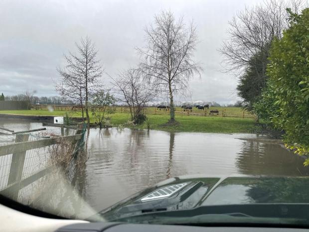
The Flood Risk Assessment identifies:
- Medium to high surface water flood risk within the site
- Areas of water pooling and low-lying land
- Ground conditions that limit natural drainage
Under the NPPF:
- Development should not increase flood risk elsewhere
- Sites should be safe for their lifetime without increasing risk
However:
- The drainage strategy is not confirmed
- It relies on future design and approval
- The feasibility of the proposed solution has not been demonstrated
This raises concerns that flood risk has not been adequately resolved.
Please submit photos in your objection.
Flood Risk and Drainage
The Flood Risk Assessment identifies:
- Medium to high surface water flood risk within the site
- Areas of water pooling and low-lying land
- Ground conditions that limit natural drainage
Under the NPPF:
- Development should not increase flood risk elsewhere
- Sites should be safe for their lifetime without increasing risk
However:
- The drainage strategy is not confirmed
- It relies on future design and approval
- The feasibility of the proposed solution has not been demonstrated
This raises concerns that flood risk has not been adequately resolved.
Please submit photos in your objection.
Ground Stability and Coal Mining Risk
The application confirms that the land sits within a Coal Mining Development High Risk Area.
This means there is a known legacy of underground mining that can affect ground stability.
What the developer’s report identifies
The submitted Coal Mining Risk Assessment highlights:
- A recorded mine shaft within the site boundary
- Additional mine entries nearby
- Shallow coal workings beneath the site
- The possibility of unrecorded workings
- Geological faulting across the site
These are identified as high hazard risks within the report.
What has NOT been done
Despite identifying these risks, the application does not include:
- Any intrusive site investigation (boreholes or drilling)
- Confirmation of the location or condition of the mine shaft
- Verification of ground stability
Instead, the report recommends:
- Further investigation
- Possible remediation measures once more information is available
Why this is a concern
This means the application is based on:
- assumptions
- historical records
- unverified data
The actual condition of the ground is unknown
Where mine shafts and shallow workings exist, there is a risk of:
- ground collapse
- subsidence
- long-term structural instability
What planning policy requires
Under the National Planning Policy Framework:
Land must be suitable for development
Planning decisions should ensure that a site is suitable for its proposed use, taking account of ground conditions and risks.
Development should not be put at risk
Planning decisions should prevent development where there are unacceptable risks from land instability.
Additional guidance
The The Coal Authority requires that:
- Coal mining risks are properly assessed
- Mine entries are identified and treated
- Ground conditions are fully investigated before development
The key issues
The application:
- identifies serious coal mining risks
- but does not investigate them properly
- and defers resolution to later stages
This means:
It has not been demonstrated that the site is safe or suitable for housing in principle.
Why this matters
This is not a minor technical issue.
It is a fundamental question of safety.
Approving development without:
- confirming ground stability
- verifying mine shaft conditions
would mean allowing development on land that has not been proven safe.
Simple takeaway
The site contains known mining hazards, but the ground has not been properly tested — safety has not been demonstrated.
Ecology and Biodiversity
The ecological assessment confirms:
- The site may support protected species
- Further surveys are required
Under the NPPF:
- Development should minimise impacts on biodiversity and provide net gains
However:
- The full ecological impact is not yet understood
- Key surveys have not been completed
This means the proposal cannot be fully assessed at this stage.
Public Right of Way
A public right of way crosses the site and is proposed to be diverted.
Planning policy requires that:
- Public access is protected
- Routes remain safe and convenient
The proposed diversion appears:
- Less direct – You need to be able to see the endpoint
- More closely integrated with roads and housing
The application does not demonstrate that the new route would provide a safe equivalent/improved experience for users.
Premature Application and Lack of Evidence
Across the submitted documents, key issues are:
- Identified
- But not resolved
- Deferred to future stages
These include:
- Ground conditions
- Drainage design
- Ecological surveys
- Final layout
Under planning principles, decisions should be based on sufficient and reliable evidence.
In this case:
- The application does not demonstrate that the site is suitable for development in principle
- Approval at this stage would therefore be premature
Final Conclusion
This application proposes development on protected Green Belt land that plays an important role in maintaining the openness and character of the area.
Across the submitted documents, significant concerns have been identified, including:
- Conflict with Green Belt policy
- Increased pressure on already congested roads
- Surface water flood risk and unresolved drainage
- High-risk coal mining conditions that have not been fully investigated
- Ecological impacts that are not yet fully understood
While these issues are acknowledged, they are not properly resolved. Instead, many are deferred to later stages, meaning the site has not been demonstrated to be suitable for development in principle.
Planning decisions should be based on clear evidence and certainty. In this case, that evidence has not been provided.
This is your opportunity to have your say.
Please review the information and submit a strong, informed objection before the deadline.
Developer promotes a proposal (Completed)
Planning application is submitted
Public consultation opens
Council decides based on policy and evidence
Before
 After
After
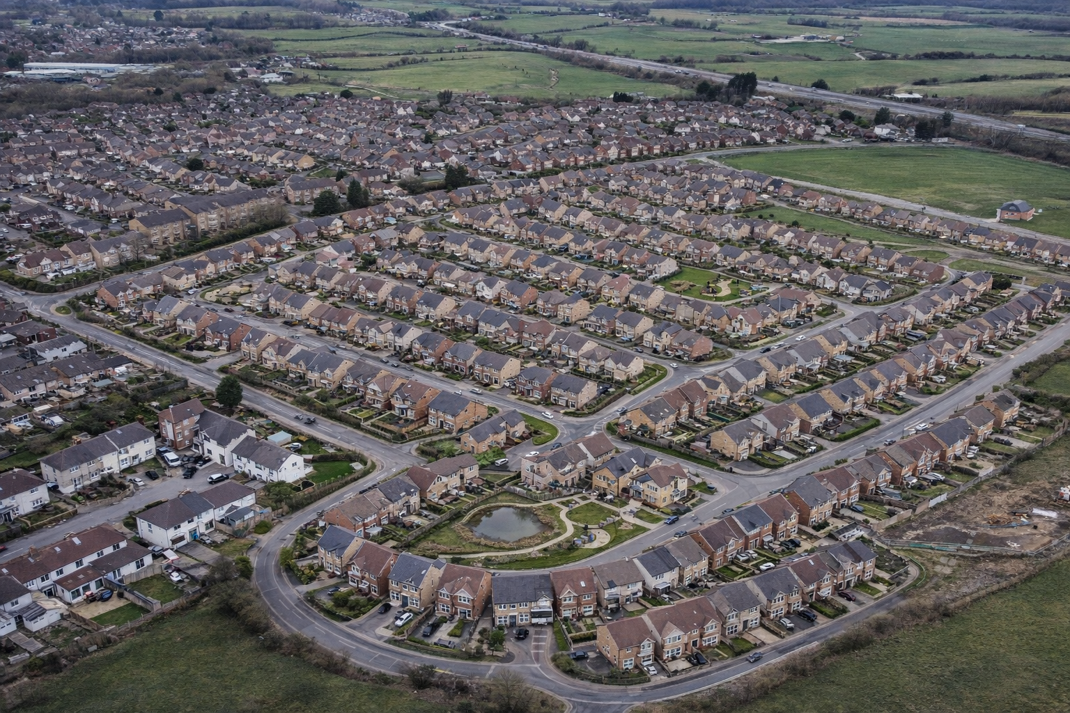
This is what could happen if no one objects
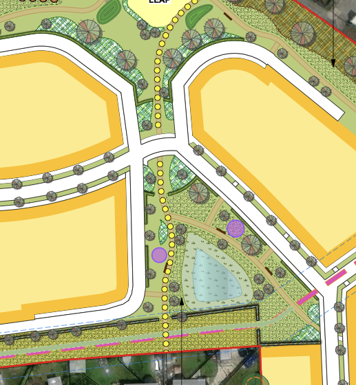
The image shows how this land could look if the application is approved.
The submitted masterplan proposes housing across much of the site, replacing open green space with roads, buildings, and infrastructure.
Once approved, this change is permanent.
If you want to protect this land, you must act now.